A guide to 12 Tampa areas, from downtown and Ybor City to Westshore and New Tampa: ZIP codes, zoned high schools and typical home values.
Last checked Oct. 10, 2026. Sources: the City of Tampa’s planning layers and neighborhood registry, © OpenStreetMap contributors, the Census Bureau’s QuickFacts for Tampa (American Community Survey 2020-2024), Hillsborough County Public Schools’ 2026-27 school zones, the Florida Department of Education’s 2026 school grades and the Zillow Home Value Index (Zillow Research).
Tampa is a big city to choose a neighborhood in. It had about 401,618 residents in the Census Bureau’s 2020-2024 American Community Survey, spread from the bayfront in South Tampa to New Tampa, more than 20 miles north by road. Fifteen ZIP codes have at least a tenth of their land inside city limits, and several of them also reach into unincorporated Hillsborough County, so a Tampa mailing address does not always mean a home inside the city.
I-275 is the spine: it runs from Westshore and the Howard Frankland Bridge past downtown and north through Seminole Heights toward New Tampa. I-4 heads east from downtown past Ybor City, and I-75 runs along the east side of New Tampa. The city does not run the schools: Hillsborough County Public Schools does, countywide, and its attendance zones do not follow city limits. Armwood High in Seffner, for example, takes in parts of East Tampa and New Tampa.
What this means for you
- Check the address, not the neighborhood name. School zones, ZIP codes and even city limits split neighborhoods. Use the district’s Find Your Neighborhood School lookup for any address.
- Home values vary widely by ZIP code. Zillow’s typical value for Tampa as a whole was $377,566 in August 2026; among the main ZIP codes in this guide it ran from $262,404 (33605) to $1,036,817 (33629).
- New Tampa is a separate commute. It is about 21 miles by road from City Hall, against 0.4 to 6 miles for the other areas here.
How the city divides itself
The City of Tampa’s planning layers split the city into five planning districts: Central Tampa, South Tampa, Westshore, New Tampa and USF Institutional, around the University of South Florida. Inside them the city has drawn nine urban villages: Ybor City, the Channel District, Tampa Heights, Seminole Heights, East Tampa, West Tampa, Hyde Park, Davis Islands and Central Park. The city’s neighborhood registry adds 160 entries, among them 87 neighborhood associations and 33 deed-restricted communities.
This guide covers 12 areas drawn from those layers. Each has its own page with zoned schools, home values, parks, interstate exits, bus routes and stores.
Every area at a glance
| # | Area | Main ZIP code | Zoned high school (share of addresses) | Typical home value in main ZIP, August 2026 |
|---|---|---|---|---|
| 1 | New Tampa | 33647 (94%) | Wharton High (48%), Freedom High (48%), Armwood High (3%) | $467,794 |
| 2 | Westshore | 33607 (61%) | Jefferson High (69%), Plant High (17%), Leto High (14%) | $362,639 |
| 3 | West Tampa | 33607 (60%) | Plant High (42%), Jefferson High (40%), Blake High (17%) | $362,639 |
| 4 | Seminole Heights | 33604 (53%) | Hillsborough High (59%), Middleton High (22%), Chamberlain High (18%) | $325,104 |
| 5 | Tampa Heights | 33602 (57%) | Hillsborough High | $519,094 |
| 6 | East Tampa | 33610 (51%) | Middleton High (80%), Blake High (11%), Armwood High (10%) | $278,011 |
| 7 | Ybor City | 33605 | Middleton High (52%), Blake High (48%) | $262,404 |
| 8 | Downtown | 33602 | Blake High | $519,094 |
| 9 | Channel District | 33602 | Blake High | $519,094 |
| 10 | Hyde Park | 33606 | Plant High | $851,969 |
| 11 | Davis Islands | 33606 | Plant High | $851,969 |
| 12 | Palma Ceia | 33629 | Plant High | $1,036,817 |
The typical home value is the Zillow Home Value Index, a modeled typical value for the middle third of homes, not a sale price, for the ZIP code that holds most of the area’s address points. Most ZIP codes also cover neighboring areas. School shares come from the district’s 2026-27 zones matched against the city’s address points. Every high school named here has its 2026 state grade on the area’s own page.
The map
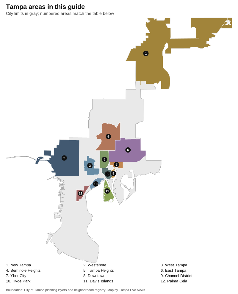
Map by Tampa Live News from the City of Tampa’s planning layers and neighborhood registry boundaries.
The areas
1. New Tampa
The city’s northern planning district along Bruce B. Downs Boulevard and I-75, made up of planned communities. All 33 deed-restricted communities in the city registry are here, among them Tampa Palms, Hunter’s Green, K-Bar Ranch and Cory Lake Isles. Read the New Tampa page.
2. Westshore
The planning district around the Westshore business district, Tampa International Airport and Raymond James Stadium, with neighborhoods such as Westshore Palms, North Bon Air and Carver City/Lincoln Gardens, and Al Lopez Park and Cypress Point Park. Read the Westshore page.
3. West Tampa
An urban village west of the river and north of Kennedy Boulevard, first incorporated in 1895 according to the city registry, right at I-275 exit 42 and split among several school zones. Read the West Tampa page.
4. Seminole Heights
An urban village north of Tampa Heights along the river, with the Seminole Heights historic district, eight city parks and centers and a branch library. Most address points have no unit number. Read the Seminole Heights page.
5. Tampa Heights
An urban village just north of downtown, partly a local historic district, with Water Works Park and the north end of the Riverwalk. All but three of its address points are zoned for Hillsborough High. Read the Tampa Heights page.
6. East Tampa
An urban village and redevelopment area north and east of Ybor City, made up of 13 neighborhoods in the city registry, including College Hill-Belmont Heights and Jackson Heights, with three public pools. Read the East Tampa page.
7. Ybor City
The historic cigar district northeast of downtown, an urban village and local historic district since 1975, with four streetcar stops and I-4 exit 1 at its edge. Read the Ybor City page.
8. Downtown
The 524-acre Central Business District on the east bank of the river, with the Riverwalk, Curtis Hixon Waterfront Park and the main library. About 91% of its address points are condo and apartment units. Read the Downtown page.
9. Channel District
A 199-acre urban village between downtown and the port, almost all apartments and condos, with two city parks, a Publix and four streetcar stops. Read the Channel District page.
10. Hyde Park
A historic urban village southwest of downtown on Bayshore Boulevard, which the city registry calls Tampa’s oldest existing neighborhood. Every address point is zoned for Plant High. Read the Hyde Park page.
11. Davis Islands
Islands in Hillsborough Bay just south of downtown, with a park, pool, tennis center, beach and two boat basins. Every address point is zoned for Gorrie, Wilson and Plant. Read the Davis Islands page.
12. Palma Ceia
A South Tampa neighborhood between Dale Mabry Highway and the Crosstown Expressway, mapped by its neighborhood association in the city registry, zoned for Plant High. Read the Palma Ceia page.
How we built this
We used only boundaries we could cite. Eleven areas come straight from the City of Tampa’s planning layers: the Central Business District for downtown, eight of the nine urban villages, and the Westshore and New Tampa planning districts. Palma Ceia follows its neighborhood association’s boundary in the city’s neighborhood registry. OpenStreetMap’s place names inside the city also list Davis Islands, Ybor City, Tampa Heights, Palma Ceia, West Tampa, Hyde Park and East Tampa. The Central Park urban village, about 158 acres between downtown and Ybor City, and the South Tampa, Central Tampa and university planning districts as a whole do not have their own pages yet. We do not rank areas or call any of them better than another.
Related: Tampa home prices, Tampa schools, moving to Tampa, getting around Tampa, property taxes and Tampa vs Temple Terrace vs Oldsmar vs Safety Harbor.
Frequently asked questions
What are the main neighborhoods in Tampa?
The City of Tampa’s planning layers name nine urban villages (Ybor City, the Channel District, Tampa Heights, Seminole Heights, East Tampa, West Tampa, Hyde Park, Davis Islands and Central Park) and five planning districts, including Westshore, South Tampa and New Tampa. Its registry lists 160 neighborhood entries.
Which Tampa neighborhoods are zoned for Plant High?
Every address point in Hyde Park, Davis Islands and Palma Ceia is zoned for Plant High for 2026-27, along with about 42% of West Tampa and 17% of Westshore. Plant earned an A in Florida’s 2026 grades.
Do Tampa school zones follow city limits?
No. Hillsborough County Public Schools draws zones countywide. Armwood High in Seffner, for example, serves parts of East Tampa and New Tampa. Check any address with the district’s Find Your Neighborhood School lookup.
How many neighborhood associations are in Tampa?
The City of Tampa’s neighborhood registry lists 87 neighborhood associations and 33 deed-restricted communities among its 160 entries.
Have your say